4 steps to build a complete 3D scan consultation

Structuring a 3D scan consultation: a founding stage of the project

Contrary to the implementation of BIM approaches for which more and more documents and best practice guides exist, scan to BIM projects do not currently rely on any protocol or quality standards.
However, consultations for 3D scanning projects from project owners, design offices, project managers and other building players are increasing.
To guarantee the success of such projects, it will be a question of knowing how to build this 3D scan consultation, and to transmit the right information concerning the entire project to the future companies consulted, in particular those concerning the specificities of the building, and the final use of the data delivered.
This will, for example, limit the risks of delays, additional costs, and the need for recovery on the deliverables produced (e.g. 2D plans; 3D models/BIM).
To guarantee a good construction of your consultations, we invite you to discover the 4 steps, which in the eyes of My Digital Buildings, allow you to develop a complete and successful consultation:
- Gather general information on the building (s) that have an impact on the 3D survey operation
- Identify specific areas of intervention
- Anticipate the necessary authorizations for the 3D survey intervention
- Understand the key points of your BIM documentation that have an impact on 3D capture
Gather general information about the building
First, it will be a question of bringing together elements allowing 3D scanning companies to know the building environment at the time of the consultation.
To do this, integrating plans and photos of the interior and exterior of buildings into your consultation will make it possible to clearly identify the surfaces and the environment in which 3D operators will be required to operate and the potential points of attention.
Then, some key specificities should be mentioned in the CDC, such as the height of the building, the different restricted heights, the number of floors, and the congestion rate of the areas.
This information will allow consultation respondents to identify what will be the best methodology and 3D scanning solutions most suited to the project (e.g. static scanners; mobile scanners; mobile scanners; drones).
As a bonus, identifying the areas to be surveyed on Google Earth will help you estimate the areas to be surveyed!
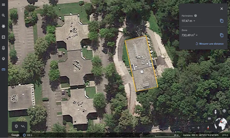
Analyze the building (s) to be scanned
Identify areas of intervention
Then, it will be a question of clearly specifying in the consultation which are the specific areas of the building, which may induce 3D capture constraints. Among the most recurrent specific areas, we can mention:
- Clean rooms with double airlocks, which are regularly found in pharmaceutical factories;
- Dusty environments, certain industrial sites or waste recovery sites;
- completely inaccessible areas;
- Roofs that are inaccessible to an operator;
- Refrigerated or very hot environments;
- Areas with a high level of activity;
- Technical plenums;
- ATEX zones.
For each of these types of areas, the survey protocol and the equipment used can be adjusted, in order to gain efficiency, evolve in safety and intervene with the right authorizations.
Anticipate the necessary authorizations for the 3D survey operation
Thus, it is important for sponsors to know the mandatory clearances, to ensure that operators will operate safely and to minimize the risk of accidents.
The most recurrent authorizations to request are:
- An H0B0 authorization (allowing unattended access to access rooms reserved for low-voltage and high-voltage electricians);
- An ATEX certification (allowing intervention in explosive atmospheres);
- A CATEC certification for working in a confined environment;
- An authorization for working at heights.

The importance of BIM documentation on capture
As part of a structured BIM approach, BIM documentation is produced by an internal BIM team, or most of the time by a BIM AMO. This BIM documentation integrates documents such as the BIM Charter, the BIM Specifications or the BIM Convention. To find out more, we invite you to read our article on this subject.
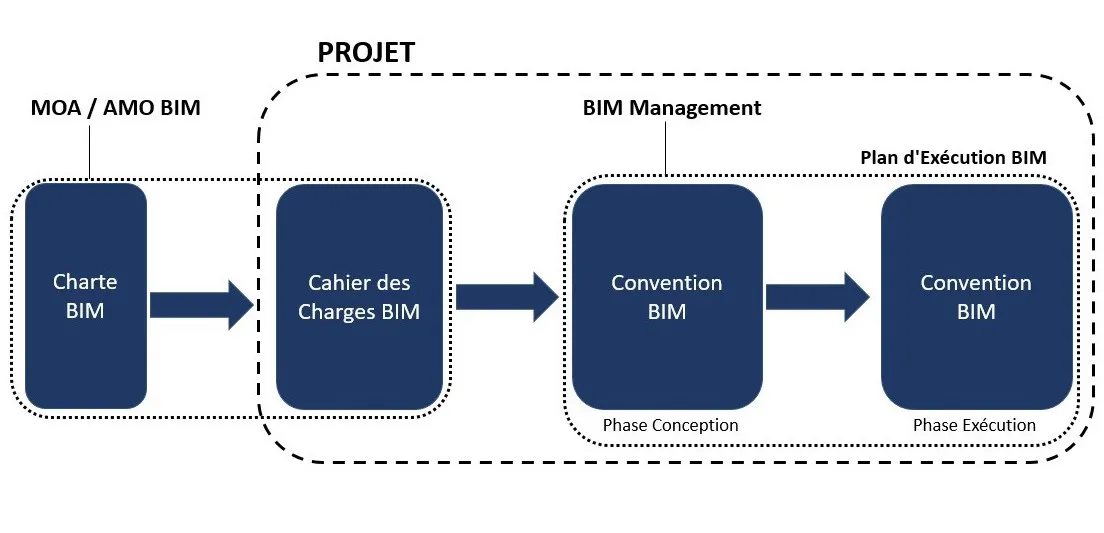
In these documents, we find in particular three key points for the 3D scanning company:
- The BIM objectives and uses of the project;
- The levels of detail and information that will be integrated into the future model;
- A component concerning the quality control of the model.
The impact of the uses and BIM objectives of the project on the 3D capture protocol
First of all, knowing the uses and BIM objectives of a project can allow a 3D survey company to select perfectly adapted capture solutions.
Indeed, if one of the BIM objectives is for example to facilitate the operation and maintenance of buildings, with as an associated use case the extraction of P&ID diagrams directly from the model, the equipment used should make it possible to collect and identify all the information related to regulatory bodies (valves, pumps, etc.). The use of a scanner taking a larger number of photos, in addition to the captured point cloud, may be wise.
Conversely, if one of the BIM objectives identified concerns communication around the project, with the associated use case being the production of an immersive virtual tour of the building, the capture equipment may be a little less accurate than in the first case. Rather, it will offer a good ability to take photos, and the use of the captured point cloud will be limited to exploitation in archi/building structure modeling.
The link between the level of detail (LOD) and the 3D survey
Second, the levels of detail and information required will also have a major role in the choice of technologies. The higher the level of detail, the more qualitative the point cloud must be to allow fine modeling. This has an impact on the one hand on the choice of scanners used, but also on the capture protocol.
Indeed, if we take up the use case of P&ID diagram extraction, the density of points captured by the scanner should be significant, and the panoramic photos captured in very high definition. This will make it possible, for example, to read the technical labels attached to the valves during the modeling phase, and to link the information visible in the photos to the BIM objects modelled.
The quality control of the model, and its impact on the 3D scanning operation
Finally, the quality control of the model will make it possible to define the georeferencing to be set up and the division of the model. This can have an impact on how to digitize the areas on site and the equipment to be provided (e.g.: GNSS rod or total station).
Thus, having a good understanding of the quality control of the model, if the BIM documentation specifies it, will allow the capture protocol to be adjusted accordingly.

In conclusion
As you will have understood, transparency and the dissemination of key information will allow your 3D scanning provider to work at their best.
Obviously, all of this information is not mandatory for the smooth running of a project. Confidentiality issues, or the fact that certain documents have not yet been established (such as BIM documentation, which only covers BIM projects) will reduce the volume of information that can be transmitted.
Once your consultation is well structured, we obviously recommend that you compare several providers. In our opinion, their understanding of your challenges and the quality and clarity of their proposal will be 3 good indicators of choice.

Let's study your project together
Contact us, we will study your project to provide you with an estimate as soon as possible
Contact us
To make sure you don't miss out on our news, subscribe to our newsletter now!
Receive quarterly updates directly in your inbox to stay informed about the latest news and events at My Digital Buildings.


