
A modeling process in "Scan to BIM", guaranteeing a faithful representation of the reality of your buildings.

A modeling managed by a team of experts in building and BIM management, ensuring the production of a deliverable aligned with your business uses.
Detailed understanding of your use cases to ensure deliverables meet appropriate geometric and informational detail requirements.
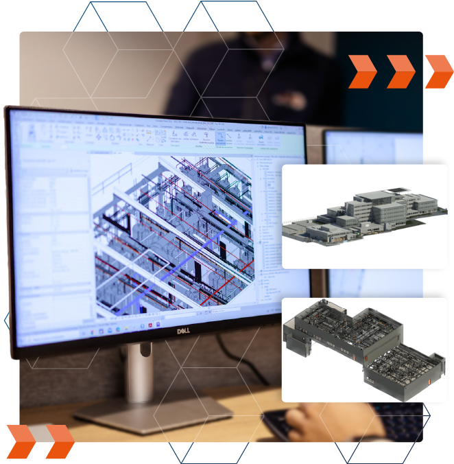
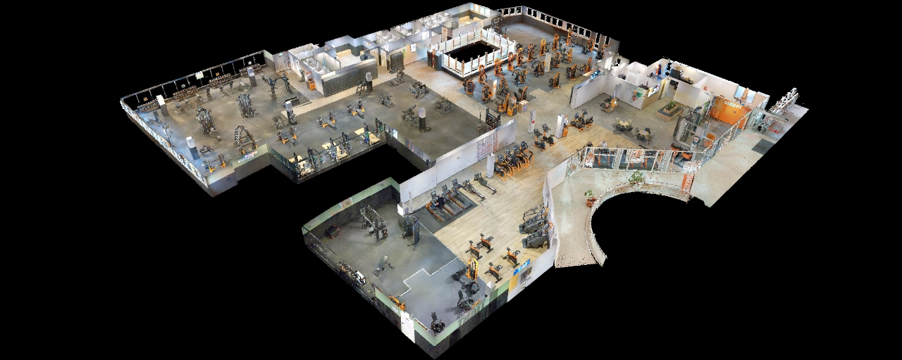
3D/BIM modelling of your buildings
A reliable Scan-to-BIM modelling process for your projects
As part of our modeling projects, we use the point cloud as the modeling layer to ensure the production of an accurate 3D model (the Scan-to-BIM process).
Point clouds, the raw data collected by 3D scanners, represent a true 3D fingerprint of the buildings—including architectural and structural elements—and all their internal components (MEP/HVAC elements, etc.).
By adhering to this modeling process, building elements are represented with exceptional precision.
An BIM model aligned needs.
At the start of the project, we study your objectives to define the actionable deliverables that support your business needs.
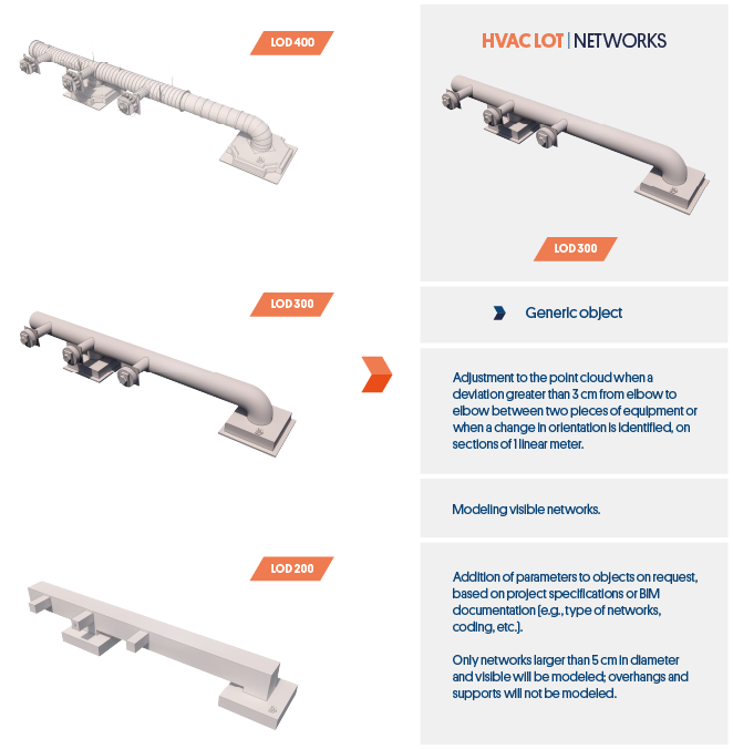
To do this, the modeling will be carried out using a clear structure (data tree, georeferencing, etc.) and predefined geometric and informational levels of detail (LOD/LOI) for each represented element.
Benefit from continuous control
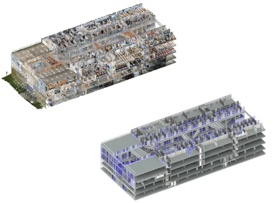
Throughout the modeling process and before final delivery, we use the point cloud to perform geometric conformity checks on the model.
During these checks, the point cloud is compared to the 3D model to identify the geometric differences between the modeling and real-world conditions.
This method allows us to achieve a precision of ±1 cm (and up to ±2 cm for complex objects) relative to the original survey data.


“My Digital Buildings’ intervention made it possible to scan more than 70,000 m² in a few weeks, providing a precise point cloud and a 360° tour accessible to all stakeholders involved in the transformation, operation and maintenance of the station concerned by our project.”
"We were fully satisfied with our collaboration with My Digital Buildings. Their responsiveness, the quality of the 3D surveys, and the reliability of the deliverables greatly facilitated our monitoring and planning work."
Let's study your project together
Contactez-nous, nous étudierons votre projet pour vous établir un devis dans les meilleurs délais.
Contact us


Q&a
Any questions you'd like answered?
Contact usWhat is a digital model?
A digital model is a geometric representation of a building, composed of 3D objects representing architecture, networks, equipment (furniture, machines, etc.) forming together a 3D replica of the existing one. They may also include more or less information depending on the use of the model.
Depending on the project and the needs identified among the stakeholders, it will be a question of defining the elements to be modelled, and the associated levels of detail in the project specifications.
What is BIM?
BIM is the acronym for Building Information Modeling. It is a collaborative way of working centered on the digital model of a building and the information associated with it. To carry out a BIM approach, the digital model must integrate an organized database of building information, and a specific coordination mode must be defined.
This way of working covers the entire life cycle of the structure: design, construction, management, operation, maintenance and demolition. Thus, all building actors (architecture firms, design offices, operators, residents, etc.) can benefit from it.
What is the level of detail (LOD) of a 3D model?
The level of detail (or LOD - Level Of Detail) corresponds to the geometric precision of a model, defined by the precision of the 3D objects it contains. This level of precision makes it possible to obtain a greater or lesser degree of geometric information. It can be adapted zone by zone or by category of elements represented in the model to adapt to the specificities of a project. There are 5 different LOD levels (LOD 100, 200, 300, 400, and 500).
Although no strict nomenclature exists, certain classical uses emerge for each of these standards in the design, construction and operation phases. To find out more about this subject, we invite you to discover our two articles: “Define the level of detail (LOD) of your BIM model” and “BIM modeling: focus on the levels of detail of networks and terminals”.
What documents govern a BIM process?
A set of documents governs a BIM process by covering the life cycle of the structure. Among them, we can list the specifications document, the charter and the BIM Convention.
Their role is to guarantee compliance with the BIM objectives set by the project owner and to organize coordination between the various entities working around the 3D model.
To find out more about this, we invite you to read our article on BIM documents.
Which formats are available?
Since digital models are created in specific software, they have a format called ”native” corresponding to each software (Revit, Autocad, Allplan, etc.).
In our BIM modelling process, the export can be done in interoperable format (IFC) or in the native format of the Revit software, which is the one we use to model. On this subject, we also offer you an article to better understand the challenges around digital model formats.
When it comes to creating 2D plans, we use Autocad and offer plans in .DWG format.
How do I use the point cloud to model?
The building point cloud is used as a 3D layer of reality during the modelling and quality control phases of the 3D model.
It thus makes it possible to rely on a precise and representative footprint to produce a model.” As-Built ” . We are talking here about a scan to BIM method.
During the quality control phase of the model, the captured point cloud will be used to detect:
- Missing surveyed areas;
- Discrepancies between the point cloud and the model;
- Errors in interpreting the object being modelled.
- On site, the preparation and digitization of areas;
- Post-processing and exploitation of captured data
These various control methods will make it possible to produce a quality deliverable that complies with the modeling specifications.


