3D scanning: an innovative solution for the study of aftermath fires


Fire, flood, hail, lightning: natural or accidental hazards that can alter the condition of a building are numerous, as are the actors in the future study and restoration project. Indeed, insurance experts, policyholders, structures, decontamination experts, decontamination experts, diagnosers and MOE will follow one another to assess the damage and initiate potential rehabilitation.
Insurance experts will be the first to go on site to see the damage, before other actors can visit the site later.
These visits, which are often rapid or restricted, do not always allow you to have all the information concerning the site, although access to the site will then be very limited. The lack of visibility and accurate information that this creates will make the post-disaster restoration project more complex, from estimating the damage to designing the renovation project.
Freeze the condition of a building to a Instant t And recording existing information is therefore particularly interesting, and that is exactly what 3D scanning solutions Allow.
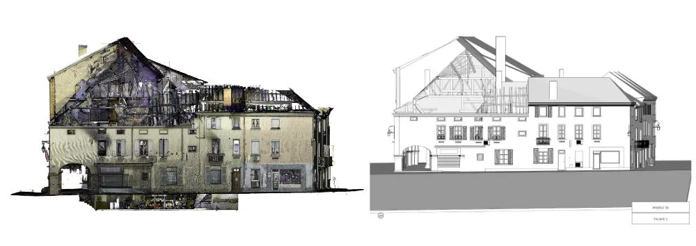
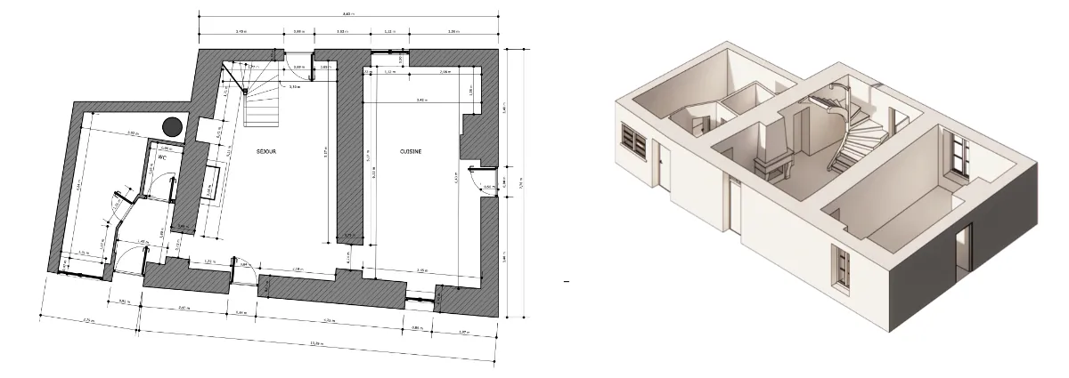
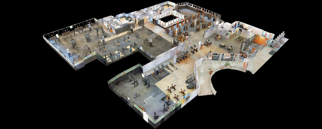
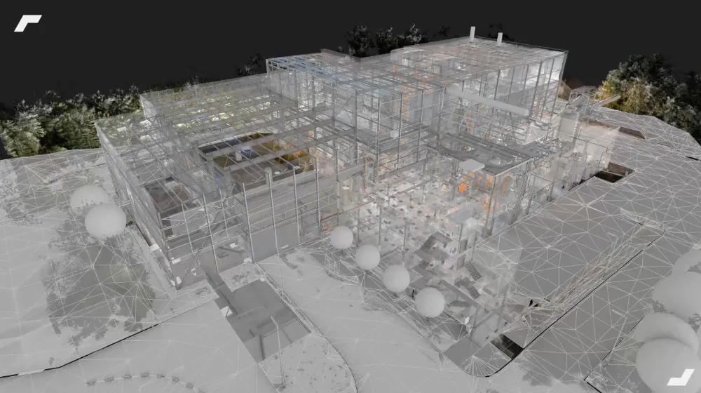
By conducting a 3D survey of a damaged building, a digital replica of the building is created, in various formats: in 2D (plans), in 3D (model or textured models) or as a virtual visit.
What is a post-disaster 3D scanning operation?
To conduct a 3D survey of the existing situation following a disaster, the project managers will need to call on a specialized company that will intervene on site equipped with 3D scanners.
Proud successors to laser rangefinders, 3D scanners allow rapid surveys of the environment, and to generate 3D data (point clouds) and 360° panoramic photos.
The intervention must be carried out as soon as possible by following a reinforced security protocol, so that areas that are unstable and subject to deterioration are faithfully identified. Operators will have to secure areas if necessary, and wear technical equipment (suits, glasses or masks, etc.) in order to protect themselves.

Following this intervention, the data generated will be used to produce various deliverables that will prove to be very useful for the rest of the project:
- 2D plans and a 3D model, to quantify surfaces and volumes and work on the design of the future rehabilitation project;
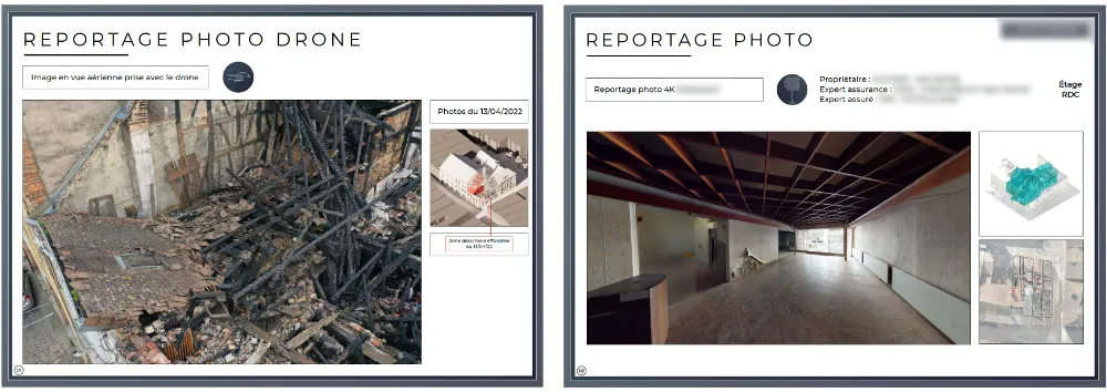
- A virtual visit, allowing you to navigate the building, centralize information and take measurements remotely;
- A textured 3D rendering, to inspect the disaster site from an aerial view
From the estimation of the damage to the completion of a post-disaster file, these various deliverables will greatly simplify the task of the various actors. We detail the main uses and returns on investment below.
Dematerialized access to the damaged building
Accurately estimate damage
By using 2D plans to measure surfaces and 3D models to calculate volumes, the estimate of damage and restoration costs will be very accurate. Moreover, these estimates can be carried out remotely without risking a false assessment.
Finally, it is the virtual tour that can be used to inspect the building, in a way that is very complementary to plans and 3D models because of the ease of navigation it offers.
In addition to navigating the building, the virtual visits we offer also allow you to take measurements or to centralize information in them. These functionalities can be particularly interesting for structural, diagnostic and MOE experts to anticipate site access constraints and conduct their studies.
Search for the causes of the disaster
Identifying the causes of a disaster can be complicated, especially when the site continues to deteriorate after the disaster, or when objects and equipment are removed from the scene.
Once again, a capture of the environment at a given moment, and as close as possible to the disaster, will make sense, especially since the various supports created will allow to have a different point of view on the building.
The virtual interior tour will allow you to inspect the building in every detail, while the textured 3D models and aerial views will allow you to gain height and inspect the surroundings of the building.
Illustrated reports and diagnostics
Finally, the various 2D and 3D renderings can be integrated into the project file, making it possible to illustrate analyses and diagnoses.
The reader will thus benefit from a better understanding of the spaces, volumes and surfaces by browsing the file, in which links can be made to the virtual building (by adding simple URLs in particular). Depending on the rights granted to him, the recipient of this report will thus be able to access the virtual building directly and contextualize the information that is exposed to him.
Benefits that can be shared by all the actors in the project
Thus, post-disaster 3D scanning operations offer obvious benefits for project actors. Among these, we can mention in particular:
- The acquisition of very precise data, which makes it possible to produce reliable and realistic working materials;
- A reliability of the post-disaster audit at a lower cost;
- The improvement of post-disaster files, with visual content and illustrations;
- Avoid exposing experts to the risks of an unstabilized site;
- A reduction in the number of trips on site;
- Access to rich data, very quickly after the disaster.
A single capture at the start of the project will be necessary to produce the deliverables mentioned in this article (plans, 3D model, textured model and virtual tour). Its cost could even be shared between the various project stakeholders who will use these work supports for different uses.
What to remember
The 3D scan of the existing is a quick and effective solution to freeze the condition of a building. These technologies are also intended to be more and more accessible, in particular thanks to the appearance of 3D scanners that make it possible to quickly identify large spaces (up to 12,000 m²).2).
Freezing the existing and recording digitally the reality of the disaster will be very interesting for the actors of the study project. They will thus benefit from a common framework for inspecting the building and carrying out their diagnostics and analyses.
This digital archive also guarantees constant access to the building during procedures and studies, without constraints on site security or schedules.
The areas of return on investment are multiple. The reduction in the number of site visits and the acceleration of studies are two first quantitative indicators. At the same time, the improvement of post-disaster files, the security of project actors and the reliability of analyses are qualitative indicators that should not be overlooked.
Finally, the sharing of digital duplicates between the various actors opens up the possibility of dividing the costs between the different companies involved in the project. Obtaining a return on investment is then guaranteed.
To find out more
Let's study your project together
Contact us, we will study your project to provide you with an estimate as soon as possible
Contact us


To make sure you don't miss out on our news, subscribe to our newsletter now!
Receive quarterly updates directly in your inbox to stay informed about the latest news and events at My Digital Buildings.


